Source status

Published records retain source and verification context.

Japan / city

Kamakura

鎌倉市

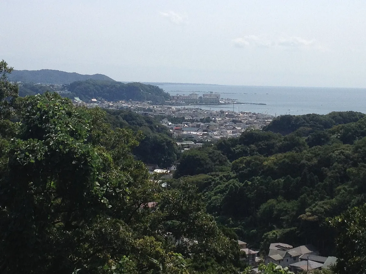
Kamakura city and coastline seen from the surrounding wooded hills
From the hills, Kamakura's compact city, wooded edges and coast read as one landscape.Photo by Daniel M. Dobkin via Wikimedia Commons; resized and converted to WebP · Wikimedia Commons (opens in a new tab) · CC BY-SA 4.0 (opens in a new tab)

Kamakura is a coastal temple city about an hour from Tokyo, where samurai-era history, major shrines, hillside temples and compact rail-based sightseeing meet.

Recommended stay
12 days
Trip role
day trip
01

Why it fits

A place in the route, not just a pin on the map.

Kamakura brings major shrines and temples, samurai-period history, hillside neighborhoods and the coast into a practical rail day trip from Tokyo. A first visit can combine Tsurugaoka Hachimangu around the central station area with the Great Buddha and Hasedera on the Enoden side of the city. Official JNTO guidance frames a representative route as one full day, while a second day or overnight can reduce the need to compress distant areas into the busiest hours. Flower seasons, New Year visits and event periods change demand, and coastal weather can affect outdoor walking. Check current rail, bus, temple and shrine information before travel.

Best when

Best for travelers interested in temples, samurai history, coastal walks and a car-free day trip from Tokyo, with enough flexibility to move between separate sightseeing areas.

Think twice when

Less suitable for travelers who want to avoid daytime crowds, flower-season queues or multiple local transfers, unless they can start early or stay overnight.

Decision profile / 02

What changes the trip.

Comparable fields make the trade-offs explicit without creating one overall rank.

Access

60 min

Tokyo Station is the comparison gateway. JNTO's representative itinerary gives about 55 minutes by JR to Kita-Kamakura, so this database rounds the trip to 60 minutes as a planning comparison rather than a guaranteed timetable. JR, Enoden and local buses support a car-free visit; verify current services before travel.

From Tokyo Station
Season

spring / summer / autumn / winter

Spring blossoms, early-summer hydrangeas, summer coastal activity, New Year visits and late-autumn foliage create distinct seasonal patterns. Monthly suitability is a static editorial aid based on official climate, seasonal and historical visitor sources, not a forecast or live crowd report.

Budget

moderate

Kamakura sits in a moderate editorial planning band for this database. Rail and bus fares, temple admissions, food and lodging vary by route and date, so confirm current prices before travel.

Crowds

seasonal

Use this profile as a planning signal, then check dated local conditions.

Day-trip fit5/5
Overnight fit3/5
Public transport5/5
Car need1/5
First visit4/5
Family4/5
Solo5/5

Month by month

Three signals across the year.

Weather fit and seasonal value use 5 for a stronger planning signal. Crowd level uses 5 for stronger expected pressure; it is a static editorial signal, not live congestion or a cross-city rank.

Monthly weather fit, seasonal value and crowd level for Kamakura. Each factor is shown separately on a one-to-five scale.
FactorJanFebMarAprMayJunJulAugSepOctNovDec
Weather334555333554
Season445535443455
Crowd534135121452

Planning notes / all 12 months

What each month changes.

These are static, source-led planning notes—not forecasts or live crowd reports. Recheck weather, events and operations before travel.

01

January

Weather
3/5
Season
4/5
Crowd
5/5

Cool coastal-proxy conditions overlap New Year interest; annual shrine and transport operations require a current check.

02

February

Weather
3/5
Season
4/5
Crowd
3/5

Cooler conditions and a lower historical demand signal support a quieter editorial profile; the climate source is nearby Tsujido, not Kamakura.

03

March

Weather
4/5
Season
5/5
Crowd
4/5

Milder spring conditions and blossom interest raise seasonal value; bloom timing changes each year.

04

April

Weather
5/5
Season
5/5
Crowd
1/5

Comfortable spring conditions support outdoor sightseeing; historical city counts remain a static comparison.

05

May

Weather
5/5
Season
3/5
Crowd
3/5

Mild late spring overlaps holiday demand signals; current transport and venue schedules remain outside this profile.

06

June

Weather
5/5
Season
5/5
Crowd
5/5

Rainy-season hydrangea interest overlaps wetter conditions and seasonal entry procedures that require a dated check.

07

July

Weather
3/5
Season
4/5
Crowd
1/5

Warm, humid summer conditions support coastal activity but do not represent live heat risk, beach operations or daily demand.

08

August

Weather
3/5
Season
4/5
Crowd
2/5

Peak heat and holiday-period activity require current weather and transport checks; the static profile does not model daily conditions.

09

September

Weather
3/5
Season
3/5
Crowd
1/5

Warm, wetter early-autumn conditions raise storm risk; typhoon effects and closures are outside this profile.

10

October

Weather
5/5
Season
4/5
Crowd
4/5

Mild autumn conditions support walking, while event timing and daily crowd conditions require separate checks.

11

November

Weather
5/5
Season
5/5
Crowd
5/5

Cool autumn and foliage interest raise seasonal value; the historical demand signal is not a forecast of current congestion.

12

December

Weather
4/5
Season
5/5
Crowd
2/5

Cooler, drier conditions overlap year-end interest; temple, shrine and transport schedules require current verification.

In-depth guide

Know the place before you go.

Detailed, source-led context for planning the visit—not a substitute for current official notices.

01

context

How Kamakura Fits Together

Kamakura is compact on a regional map but divided into distinct sightseeing clusters. Hills enclose the historic basin on three sides and Sagami Bay opens to the south. This geography helped shape the former samurai capital and still determines how visitors move: rail lines use the north–south corridor and the coast, while temples, residential streets and hiking routes extend into the surrounding valleys and ridges.

JR Kita-Kamakura Station is the practical gateway to the northern Zen-temple area. The next stop, Kamakura Station, anchors the busiest central district: Komachi-dori runs toward the shrine side, Wakamiya Oji forms the ceremonial axis, and Tsurugaoka Hachimangu stands north of the station. Hase and Yuigahama are separate western and coastal clusters reached by the Enoden, bus or a longer walk. Kanazawa-kaido lies east of the center and is generally approached by bus.

The result is a city that rewards directional planning. A station-area loop can be walked, and Hasedera and the Great Buddha pair naturally around Hase, but crossing repeatedly among Kita-Kamakura, Hase and the eastern temple corridor consumes time. Treat each as a half-day-scale zone rather than assuming every famous site belongs to one continuous pedestrian circuit.

  • Kita-Kamakura: northern rail gateway and major Zen temples.
  • Kamakura Station: central shopping streets, museums and Tsurugaoka Hachimangu.
  • Hase and Yuigahama: Great Buddha, Hasedera, Enoden and the coast.
  • Kanazawa-kaido: an eastern temple corridor where buses are useful.
  • Hills and hiking routes: separate outdoor plans, not shortcuts for every traveler.
02

highlights

Choose the Kamakura Area That Matches Your Priorities

Choose the Kamakura Station area for the broadest first-visit mix. It combines the approach to Tsurugaoka Hachimangu with Komachi-dori, Wakamiya Oji and cultural facilities. It is also the easiest place to change between JR, Enoden and local buses. The trade-off is concentration: the official destination guide identifies overtourism in parts of the compact townscape, and this central axis is often where day-trip traffic gathers.

Choose Kita-Kamakura when Zen history, temple grounds and a quieter opening to the day matter more than shops or the beach. JR serves the area directly, and official listings place Engakuji, Jochiji and other temple sites in this northern cluster. Choose Hase for the Great Buddha and Hasedera, then continue to Yuigahama if the coast is part of the trip. The Enoden connects Hase with Kamakura and runs west along the seaside toward Enoshima.

Choose Kanazawa-kaido for temples such as Hokokuji, Jomyoji and Sugimotodera, understanding that the sights form a corridor rather than a single compound. Omachi and Zaimokuza offer another direction for historic sites and the coast. In a one-day itinerary, select two main clusters. A third cluster should be an optional extension, not a fixed promise that forces every temple visit into a short stop.

  • Best first-time overview: Kamakura Station plus either Hase or Kita-Kamakura.
  • Best temple-focused start: Kita-Kamakura before continuing south.
  • Best coast-and-landmark pairing: Hase plus Yuigahama.
  • Best bus-assisted alternative: the Kanazawa-kaido temple corridor.
  • Best crowd strategy: replace one headline cluster with a coherent secondary area.
03

planning

A Realistic One-Day Kamakura Itinerary

For a first visit, begin in Hase near the opening time of the places you intend to enter. Visit Hasedera and the Great Buddha as one western cluster rather than as separate cross-city trips. Their current hours, admission rules and temporary restrictions can change, so confirm the official venue information before travel. If the weather is comfortable, add a short look at the coast; otherwise continue by Enoden or bus toward Kamakura Station.

Use the middle of the day for lunch and the central historic axis. Walk Wakamiya Oji toward Tsurugaoka Hachimangu, or use Komachi-dori in one direction and the broader avenue in the other. Allow time to visit the shrine respectfully instead of treating the approach only as a shopping street. If crowds are heavy, the city’s live map can help you decide whether to reverse the sequence or spend longer in a less concentrated area.

Finish with one elective stop: a museum near the central area, an additional temple, or a calm neighborhood walk. Do not automatically add Kita-Kamakura and the full eastern corridor after Hase and the central district. This editorial route needs roughly seven to eight usable sightseeing hours, excluding the Tokyo round trip. Protect time for meals, queues, station transfers and an earlier winter finish.

  • Morning: Hasedera and the Great Buddha as one Hase-area block.
  • Late morning: optional coast stop, then Enoden or bus to Kamakura Station.
  • Midday: lunch without relying on eating while walking through narrow crowds.
  • Afternoon: Wakamiya Oji and Tsurugaoka Hachimangu.
  • Final choice: one museum, temple or quieter street—not another full district.
04

planning

How to Spend Two Days Without Repeating the Same Route

On day one, start at Kita-Kamakura Station and select two northern temple grounds rather than trying to complete every listed site. Continue south toward the central district by train, bus or a planned walk, depending on mobility and weather. Use the afternoon for Tsurugaoka Hachimangu, Wakamiya Oji and one cultural facility. An overnight stay makes an early or evening walk possible after much of the day-trip traffic has left.

On day two, focus on Hase and the coast. Visit the Great Buddha and Hasedera, then decide between Yuigahama, a slower Enoden journey west, or time in the streets around Hase and Gokurakuji. Travelers who prefer gardens and temples to the seaside can instead give the second afternoon to the Kanazawa-kaido corridor. This eastern option requires attention to current bus times and venue closing hours.

Enoshima can replace, but should not be stacked on top of, the second afternoon. The Enoden links the Kamakura side with Enoshima Station, and a one-day line pass may be useful only when the planned rides justify it. Two days should create depth and resilience: leave room for rain, seasonal queues, a long temple visit or a changed trail plan rather than doubling the number of checklist stops.

  • Day 1 morning: two selected Kita-Kamakura temple grounds.
  • Day 1 afternoon: central shrine axis and one museum or historic site.
  • Day 2 morning: Hase landmark pair.
  • Day 2 afternoon: coast, Kanazawa-kaido or Enoshima—choose one.
  • Keep hiking as a weather-dependent substitute, not an immovable connection.
05

access

Getting to Kamakura and Moving Between Its Districts

Tokyo Station is the comparison gateway used by this database. The current official access guide gives about 60 minutes to Kamakura Station on the JR Yokosuka Line; JNTO gives a similar orientation. JR also serves Kita-Kamakura, so a northern-to-central route can avoid backtracking. From Yokohama, the official guide gives about 25 minutes on the Yokosuka Line. These are planning references, not guaranteed connections.

Within Kamakura, match the mode to the district. Walk the central shrine axis, use the Enoden for Hase and the coast, and consider a local bus for Kanazawa-kaido or when walking capacity is limited. The east exit of Kamakura Station has a bus terminal with destination guidance. Roads near popular sights can be congested on weekdays as well as weekends, so the tourism authority recommends public transport instead of driving.

Unlimited-ride products cover different networks and boundaries. Buying one is not automatically cheaper or faster: compare the exact planned rides, current price and sales method on the operator or official tourism page. During peak periods, a packed Enoden or delayed bus may be less efficient than a well-chosen walk. Check live service information, allow transfer time and avoid building the day around a minute-perfect connection.

  • JR: Tokyo or Yokohama to Kita-Kamakura and Kamakura gateways.
  • Enoden: Hase, the coastal corridor and onward travel toward Enoshima.
  • Bus: useful for eastern temples and selected station-to-attraction links.
  • Walking: best within one cluster, not as a substitute for every transfer.
  • Car: generally unnecessary for the core and exposed to local congestion.
06

planning

Where to Stay: Central Access, Coast or Regional Connections

Stay near Kamakura Station when early access to the central district and simple transport connections matter most. This base works well for travelers arriving with luggage, starting a Kita-Kamakura route by JR, or using the Enoden toward Hase. It also makes it easier to experience Wakamiya Oji and nearby streets before the main day-trip wave or after many sightseeing businesses close.

Stay around Hase or Yuigahama when the coast and western sights are central to the trip. Official accommodation listings include properties in the Yuigahama–Hase–Gokurakuji area, ranging across lodging types. The trade-off is that a morning in Kita-Kamakura or an early intercity departure requires an additional local transfer. Confirm the walk from the station, late-evening transport and luggage handling with the individual property.

Ofuna can be practical for regional rail connections and may offer a different accommodation range, but it is outside the main historic sightseeing core. Enoshima or Fujisawa suits a coast-focused two-day plan more than a temple-first Kamakura itinerary. Wherever you stay, verify accessibility, meal conditions, check-in deadlines and the exact location; an accommodation labeled “Kamakura” may not be within walking distance of Kamakura Station.

  • Kamakura Station: strongest all-round base for a first overnight visit.
  • Hase or Yuigahama: best when the coast and western sights lead the plan.
  • Ofuna: useful for rail connections, with a commute to the historic core.
  • Enoshima or Fujisawa: suitable for a broader Shonan coastal itinerary.
  • Check the actual station, terrain, accessibility and final evening connection.
07

seasonality

When to Visit Kamakura—and How Seasonal Crowds Change the Day

Spring brings cherry blossoms and the Kamakura Festival period, while early summer brings hydrangea interest alongside the June–July rainy season. July and August are hot and draw visitors to the beaches; the official seasonal guide recommends morning sightseeing and cooler indoor stops during the hottest hours. Autumn foliage tends to become a late-November to early-December attraction, and New Year brings major shrine and temple visits.

These attractions create different pressure points. Hydrangea demand concentrates at flower-famous temples, summer adds beach traffic, and hatsumode changes the central shrine area. Historical monthly visitor data can explain broad patterns but cannot predict a particular hour. The city’s crowd map provides recent conditions for locations including Komachi Street, Wakamiya Oji, Hase, both sides of Kamakura Station, Kita-Kamakura and Yuigahama.

Use the month to choose a strategy, then use current information to adjust the route. Start the most important outdoor or headline site early, keep one less concentrated district in reserve and avoid assuming that a famous bloom will match a fixed calendar date. Climate values in this database use nearby Tsujido as a clearly labeled coastal proxy, not a Kamakura forecast. Check JMA forecasts, transport notices and venue updates shortly before the visit.

  • March–May: layers, blossoms and festival-related demand.
  • June–July: rain, hydrangeas, slippery surfaces and concentrated flower crowds.
  • July–September: heat precautions and increased coastal activity.
  • Late November–early December: foliage interest and shorter daylight.
  • New Year: exceptional shrine and temple demand; plan as a special period.
08

accessibility

Planning Kamakura with Children or Limited Mobility

Families can build a manageable day around one compact cluster, but Kamakura’s reputation as a walkable destination can hide accumulated distance, hills and historic-site steps. Pair two nearby places, schedule a seated meal and use rail or bus for the next district. Young children may enjoy the Enoden and coast, while a long sequence of temple interiors is less flexible. Summer heat and early-summer rain make rest points especially important.

Travelers using wheelchairs should consult the official barrier-free guidance before selecting a route. The Kamakura City Tourist Information Center provides accessibility information, accepts reservations for a limited number of attendant-propelled wheelchairs, and links to wheelchair-oriented maps. Historic temples and shrines differ substantially in slopes, gravel, stairs, toilets and accessible interiors, so a general city label cannot replace confirmation with each facility.

Strollers face similar practical constraints on narrow streets, busy platforms and rough approaches. Avoid peak movement times where possible and do not rely on a bus or Enoden carriage having generous space. A taxi can bridge a difficult segment, but road congestion still applies. Build an accessible itinerary around confirmed entrances and toilets, then add optional stops only when energy, weather and crowd conditions allow.

  • Limit each half day to one geographic cluster.
  • Verify step-free access and toilets with every historic venue.
  • Reserve a visitor-center wheelchair before relying on its availability.
  • Use the official barrier-free maps as a starting point, not a guarantee.
  • Keep a museum, café or shorter coastal stop as the low-exertion alternative.
09

nearby

Nearby Combinations: Enoshima, Yokohama or a Longer Kanto Route

Enoshima is the most natural same-region combination. The Enoden continues west from Kamakura through Hase and the coastal corridor to Enoshima Station. Give the island and its approaches a genuine half day rather than adding them after a full Kamakura checklist. In a two-day plan, base the first day on temples and the central city, then use the second for Hase, the coastal ride and Enoshima.

Yokohama is the simplest major-city pairing by rail. Official Kamakura access guidance gives roughly 25 minutes from Yokohama Station on the JR Yokosuka Line. That makes an overnight in either city workable, but it does not turn two full sightseeing programs into one relaxed day. Choose which destination gets the morning and protect the return connection.

Tokyo remains the easiest day-trip base, with the official guide using roughly one hour from Tokyo Station. Hakone and the Fuji area can follow Kamakura in a longer Kanto itinerary, but they require separate transport planning and are not efficient add-ons to the same sightseeing day. When moving onward with luggage, consider a station locker or accommodation transfer arrangement and confirm current rail or bus services.

  • Enoshima: best coastal extension, ideally a separate half day.
  • Yokohama: direct JR pairing with a short regional transfer.
  • Tokyo: practical base for a full Kamakura day trip.
  • Hakone or Fuji area: onward itinerary, not a same-day Kamakura extra.
  • Protect luggage time and the final connection when combining destinations.
10

planning

Planning Mistakes That Make Kamakura Harder

The most common mistake is counting famous places instead of geographic clusters. Kita-Kamakura, the central shrine axis, Hase and Kanazawa-kaido cannot all be explored properly in a short day. A related error is assuming “about an hour from Tokyo” means only one hour of total travel: station access, waiting, local transfers and the return trip still reduce usable sightseeing time.

Driving to avoid public-transport crowds often replaces one problem with road congestion and parking uncertainty. The official access guidance recommends public transport because roads near popular sights are busy even on weekdays. Likewise, a transit pass is useful only when its coverage matches the route. Check current operator information rather than copying an old fare, timetable or pass boundary into the plan.

Do not treat hiking trails as guaranteed transfers. Review closures and weather, wear suitable footwear, stay on marked paths and carry rubbish out. Around town, avoid stopping in a roadway or near tracks for photographs, blocking narrow streets, eating carelessly in dense crowds or disturbing residents and worshippers. At the coast, review the official hazard map and know the tsunami response. A flexible, respectful route is both safer and more likely to feel unhurried.

  • Do not plan four major districts as one ordinary day.
  • Do not assume a car will bypass peak-period congestion.
  • Do not buy a pass before checking its exact coverage and current terms.
  • Do not use a trail without current closure, weather and footwear checks.
  • Do not block roads, tracks, residents or worshippers for photographs.
  • Carry rubbish out and review coastal emergency guidance before visiting beaches.

Evidence / 04

Sources and verification

24 sources

  1. Culture on the Coast in KamakuraJapan National Tourism Organization
  2. Kamakura destination guideJapan National Tourism Organization
  3. Access to KamakuraKamakura City Tourism Association
  4. About KamakuraKamakura City Tourist Association
  5. Access to KamakuraKamakura City Tourist Association
  6. Barrier-free tourism in KamakuraKamakura City Tourist Association
  7. BOSAI KamakuraKamakura City Tourist Association
  8. Enoshima Electric RailwayKamakura City Tourist Association
  9. Getting around without the crowds in KamakuraKamakura City Tourist Association
  10. Hotels in KamakuraKamakura City Tourist Association
  11. Kamakura ItinerariesKamakura City Tourist Association
  12. Kamakura seasonsKamakura City Tourist Association
  13. Kamakura Station AreaKamakura City Tourist Association
  14. Kanazawa-kaido AreaKamakura City Tourist Association
  15. Kita-Kamakura AreaKamakura City Tourist Association
  16. Respect Kamakura GuidelinesKamakura City Tourist Association
  17. Stay in KamakuraKamakura City Tourist Association
  18. Transportation in KamakuraKamakura City Tourist Association
  19. Unlimited Ride Transit PassesKamakura City Tourist Association
  20. Yuigahama, Hase and Gokurakuji AreaKamakura City Tourist Association
  21. Kamakura City Tourist Information CenterKamakura-Fujisawa Tourism Council

Keep deciding

Place it beside another destination.

Open comparison